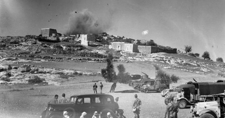
MAJDAL SHAMS, GOLAN HEIGHTS, March 7, 2017 (WAFA) – New research by al-Marsad, a Golan Heights-based human rights organization, said the number of villages Israel had destroyed after its occupation of the Golan Heights from Syria in the 1967 war is much higher than originally believed.
Al-Marsad published on Tuesday a map which it said was a product of extensive comparative research that revealed the full extent of the forcible transfer and displacement of the native Syrian population in the Golan by the Israeli occupation forces, and the destruction of their homes and communities.
It said that while previous research suggested that between 240 and 260 villages and farms in the Golan were destroyed by Israel, al-Marsad’s new research indicated that the actual number of destroyed villages and farms is much higher: 340 villages and farms.
This includes villages such as Jubathat Al-Zeht that was destroyed to make way for the development of a ski resort on Mount Hermon; and Qasrin, Shqef and Sanawber, over which the settlement of Katzrin was built.
Katzrin is currently home to various settlement businesses that illegally exploit the natural resources of the Golan, such as the Golan Heights Winery and Eden Springs / May Eden mineral water.
Al-Marsad said the discrepancy in the figures was because some of the destroyed villages and farms that had the same or similar names, but were in different locations, had not been considered in previous research.
Previous research also did not include many of the farms destroyed, likely due to a misconception that farms only contained one or two families and therefore it was not worth recording their destruction.
However, in reality the population of some of these farms was several hundred people, necessitating their inclusion in any determination of residential areas destroyed by the Israeli occupation forces, it said.
This issue was further aggravated by the absence of many farms on certain maps from the time, which meant that whilst a farm may have been destroyed on the ground, researchers would not necessarily have been aware of its prior existence depending on the maps available to them.
In addition, maps of the Golan issued by the Israeli occupying authorities intentionally ignore the demilitarized zones located along the 1949 Armistice Line between Israel and Syria, stating that these areas are part of Israel – a contradiction of the situation according to international law.
While Israel says that the area of the Syrian Golan occupied by Israel in 1967 is 1,159 square kilometer, the actual area is approximately 1,230 square kilometer, according to al-Marsad.
M.K.