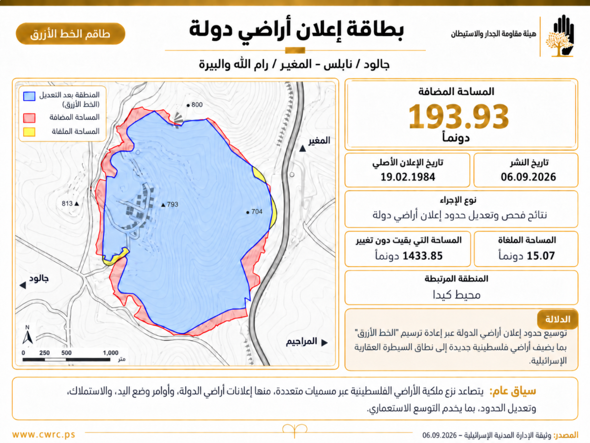
RAMALLAH, September 8, 2026 (WAFA) - The Israeli occupation authorities have expanded the boundaries of an old declaration designating large swaths of land belonging to the Nabus-governorate village of Jalud and the Ramallah-governorate village of al-Mughayyir as “state land”, according to the Colonization and Wall Resistance Commission (CWRC).
It said that the occupation authorities amended an old declaration, reclassifying 193.93 new dunams in both villages as “state land” after the so-called “Blue Line Team” approved the amendment to the declaration originally issued in 1984.
Meanwhile, the team redefined the boundaries of Palestinian land designated as “state land” as per the 1984 declaration, removing 15.07 dunams from the previous boundaries, while leaving 1,433.85 dunams unchanged. This means that the new measure is not limited to a cartographic review of the old declaration, but effectively expands the area of Palestinian land designated as “state land.”
The CWRC explained that the declaration comes amid a clear escalation in policies aimed at controlling Palestinian land and dispossessing its owners through various legal and administrative designations and mechanisms, including “state land” declarations, seizure, expropriation and confiscation orders, amendments to the boundaries of previous declarations, and the redrawing of what is known as the “Blue Line,” in addition to allocating land for colonies and the construction of roads and military sites.
It pointed out that the case of Jalud and al-Mughayyir is particularly significant because the occupation authorities did not issue a new declaration, but instead modified the boundaries of “state land” in a declaration dating back more than four decades, incorporating approximately 194 additional dunams. This pattern demonstrates how old declarations can become a basis for expansion and reinterpretation, meaning that the boundaries of “state land” do not necessarily remain fixed at the area designated when the declaration was first issued, but may subsequently be subjected to review and redrawing that could bring additional areas of Palestinian land within them.
The CWRC said that the newly designated area is located around the colonial outpost of Kida, which the occupation authorities recently approved for conversion into an official colony. Accordingly, the addition of 193.93 dunams to the “state land” declaration can be viewed as expanding the land base that could subsequently be used in the colony zoning and connecting it to surrounding infrastructure, even if the declaration itself does not constitute a decision to expand Kida’s zone of influence.
This sequence - from recognizing the outpost to redrawing “state land” around it - reveals one of the mechanisms through which colonial outposts are transformed from facts on the ground into colonies with an expandable land. This calls for treating the measure as an enabling step in the process of consolidating Kida and expanding its colonial sphere, rather than merely a cartographic correction to a declaration issued in 1984.
K.F.